Chasing
the sunshine
20 January 2021
Although cycling had been a favourite way of transport and activity even before last year, 2020 came with even more reasons to take the bike due to the COVID-19 regulations. And while there are plenty of routes to take to get out of the city, at some point it does call for some creativity to find some fresh views to keep me company on my solo rides. On the longest day of the year I planned to go – like many other cyclists – on an all-day summer solstice ride, but where to go this time? I decided to give this navigation task to the sun.
On the 20th of June, I cycled with no pre-planned route towards the sun from dusk till dawn, keeping my own pace, without any intention to go fast or very far and having breaks whenever I felt like I needed them. I documented this with taking photographs facing the north on the hour and at sunrise, midday, and sunset. This resulted in a series of random images which are not random at all. An experiment to let time and pace decide my route and images. It felt nearly impossible to be precise and not to cheat, and I still see a lamppost exactly at the center of a shot and unsure if that's the true north but I did my best and it comes close ;)
And if you wonder, I never reached the sun – it went down before I got there.

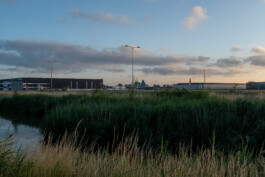


time: 5:22am
km: 7.6
location: 51°58'36.37" N 4°31'35.21" E
☼ elevation: 0°
☼ azimuth: 48.4°
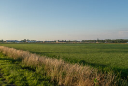
note: Sunrise. Got lost already.
time: 6am
km: 18
location: 52°1'14.87" N 4°36'53.2" E
☼ elevation: 4°
☼ azimuth: 55.6°
note: Is it coffee time yet?
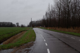
time: 7am
km: 34.2
location: 52°3'40.44" N 4°46'56.1" E
☼ elevation: 12.8°
☼ azimuth: 68°
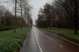
note: Hike a bike
time: 8am
km: 51.7
location: 52°6'16.98" N 4°58'14.94" E
☼ elevation: 21.6°
☼ azimuth: 79.2°
note: Time flies and I go slow when having fun!
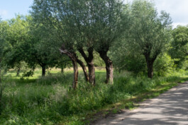
time: 9am
km: 65.8
location: 52°5'35.19" N 5°7'32.75" E
☼ elevation: 30.4°
☼ azimuth: 90°
note: Coffee
time: 10am
km: 76
location: 52°5'26.76" N 5°12'4.87" E
☼ elevation: 40°
☼ azimuth: 103.5°
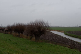
note: Trying hard to go east.
time: 11am
km: 89.1
location: 52°4'13.04" N 5°21'22.2" E
☼ elevation: 42.7°
☼ azimuth: 107.6°
note: I love the sound of the surface.
time: 12noon
km: 105
location: 52°1'9.46" N 5°32'55.95" E
☼ elevation: 56°
☼ azimuth: 139°
note: city centres
time: 1pm
km: 113.6
location: 51°57'55.44" N 5°37'5.06" E
☼ elevation: 60.5°
☼ azimuth: 161.5°
note: Peanutbutter sandwich
time: 1:39pm
km: 122.6
location: 51°57'39.43" N 5°41'21.47" E
☼ elevation: 61.5°
☼ azimuth: 180°
note: Midday, river in my way.
time: 2pm
km: 124
location: 51°56'49.17" N 5°41'30.7" E
☼ elevation: 61.3°
☼ azimuth: 191.5°
note: Fresh cherries
time: 3pm
km: 140.8
location: 51°52'7.82" N 5°42'13.47" E
☼ elevation: 57.5°
☼ azimuth: 216.8°
note: Another hour, another river
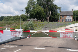
time: 4pm
km: 151.9
location: 51°49'17.59" N 5°37'49.77" E
☼ elevation: 50.9°
☼ azimuth: 257°
note: Suspended ferry, time for a refreshment!
time: 5pm
km: 157.7
location: 51°49'38.54" N 5°33'59.45" E
☼ elevation: 42.8°
☼ azimuth: 252.4°
note: Welcome in Brabant
time: 6pm
km: 174.6
location: 51°45'41.09" N 5°26'15.3" E
☼ elevation: 33.7°
☼ azimuth: 265.8°
note: Dead end roads. Nearly heading west.
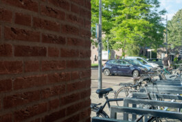
time: 7pm
km: 186
location: 51°43'48.99" N 5°19'34.68" E
☼ elevation: 24.3°
☼ azimuth: 277.6°
note: Groceries
time: 8pm
km: 202
location: 51°44'9.81" N 5°8'31.81" E
☼ elevation: 15.4°
☼ azimuth: 288.5°
note: River route
time: 9pm
km: 209.5
location: 51°45'50.95" N 5°5'54.58" E
☼ elevation: 6.8°
☼ azimuth: 299.7°
note: After dinner hours.
time: 10pm
km: 227.8
location: 51°50'12.19" N 4°56'21.9" E
☼ elevation: 0°
☼ azimuth: 310.9°
note: Golden hour
time: 10:02pm
km: 228.2
location: 51°50'14.03" N 4°56'0.12" E
☼ elevation: 0°
☼ azimuth: 311.3°
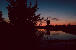
note: Sunset! Nice & simple.
time: 11pm
km: 241
location: 51°54'14.73" N 4°50'25.71" E
☼ elevation: -6.7°
☼ azimuth: 323°
note: The day is still going. Found a nice bivvy spot. Thanks for reading!
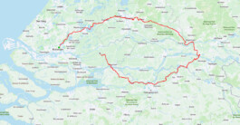
The route as guided by the summer sun
The shortest day of the year
So this summer solstice project made me curious about how it would be on the shortest day of the year. Winter solstice 2020 fell nicely on the 21st of December. Or actually, not nicely at all, as the weather the day before and the day after was much better than that particular Monday. It was miserable out there, grey, wet and windy. But after some hesitation I started riding my bike at sunrise in the direction of the sun, as shown on several apps and with help of a compass. I soon figured out the north wasn't always the same on the three devices I took with me so I trusted the compass a few steps away from other stuff. After a while the rain slowly started passing my raincoat but I still had fun, cycled roads I had never had been before and it even felt a bit eerie to be in the middle of the quiet countryside in this weather, like you're not supposed to be there.


Behind the scenes
Behind the scenes
I had a constant battle between my thoughts to continue until sunrise and take a train home later at night (COVID rules: is it a necessary trip?) and other thoughts about the project not being perfect anyway and better to quit and cycle back. At some point, sometime when the sun was on its way going down, preparing to do a better job elsewhere, I had a minor brake problem, started to get too cold and turned around to make my way back home. Like I saw a huge sun above Rotterdam in a lucid dream! Unfortunately I missed one image when I was trying to fix my brakes for a second time. A kind farmer offered me to keep dry in his shed and for me, this project was done, finished and failed at the time. At sunset (the time when grey became dark grey!) I took one last photo.
I said I'd let the sun and my pace do the navigation task and this is just what the sun did to me; he let me a bit down on this day :)


time: 8:47am
km: 0
location: 51°56'7.03" N 4°28'21.24" E
☼ elevation: 0°
☼ azimuth: 129°
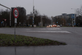
note: Made it outside on time.
time: 9am
km: 1.4
location: 51°55'46.52" N 4°29'15.54" E
☼ elevation: 3°
☼ azimuth: 135°
note: Raindrops.
time: 10am
km: 13.7
location: 51°53'9.26" N 4°34'49.67" E
☼ elevation: 7°
☼ azimuth: 144°
note: Startup struggles.
time: 11am
km: 23.5
location: 51°49'24.85" N 4°37'31.17" E
☼ elevation: 12°
☼ azimuth: 157°
note: Don't do this if you want to ride far and fast.
time: 12 noon
km: 36.3
location: 51°45'17.85" N 4°39'50.51" E
☼ elevation: 14°
☼ azimuth: 171°
note: Coffee break. Again.
time: 12:40pm
km: 44.9
location: 51°42'14.77" N 4°38'23.23" E
☼ elevation: 15°
☼ azimuth: 180°
note: Midday.
time: 1pm
km: 7.6
location: 51°41'36.88" N 4°38'16.82" E
☼ elevation: 15°
☼ azimuth: 185°
note: Most clothes are still dry. I think?
time: 2pm
km: 62.9
location: 51°35'42.05" N 4°34'20.61" E
☼ elevation: 13°
☼ azimuth: 199°
note: In summer you call this a gravel path.
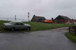
time: 3pm
km: 73
location: 51°37'40.95" N 4°30'51.66" E
☼ elevation: 9°
☼ azimuth: 212°
note: Quit. Tailwind back!
time: 4:34pm
km: 99.8
location: 51°47'8.88" N 4°27'18.75" E
☼ elevation: 0°
☼ azimuth: 231°
note: Sunset. The time when grey turned into dark grey.
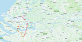
The obviously much shorter winter solstice route until sunset, with the orange not according to the plan.
© Willy Lamers, 2026